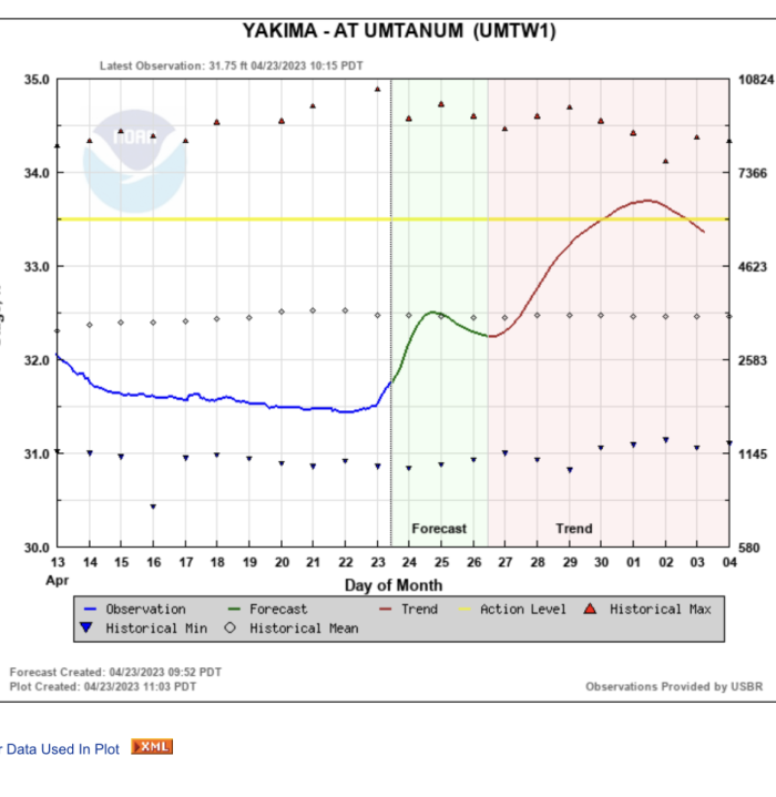
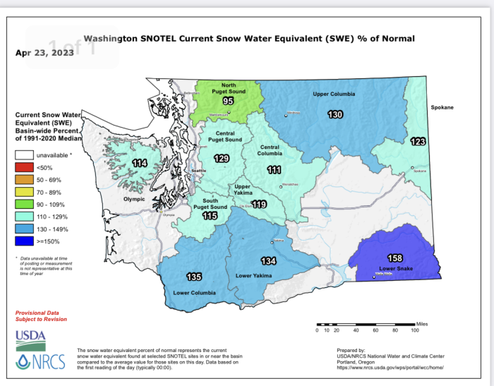
We are going to see some big fluctuations over the next month and a half….One of those fluctuations is starting right now with this warmer weather pattern
Here is the graph for the next week plus….in addition a basic explanation of the river system and the management of it.


The Yakima is a managed flow river. From the first of September through the early spring the river flows at a mandatory minimum or more depending on releases related to the Bureau of Reclamation forecasts for influx into the reservoir; this is especially true in the late winter and early spring. During late spring and summer the river flows based on the irrigation needs of the water rights and the need to make room for the snow melt into the reservoir. In a low snow pack year the reservoirs will most likely not ever fill to capacity. In a large snow pack year the reservoirs may fill to capacity and H20 may need to be released to simply make room for more anticipated storage needs. It is basically a strategic guessing game based on stats, upcoming weather and capacity levels. The goal of the B of R is to make sure the reservoirs are as full as possible at the end of run-off as well as to meet mandatory minimum flows for fish habitat. Every year around the first of September the B of R performs what is referred to as the flip flop. This is when the Yakima flows are decreased from the demands of the high irrigation flows of summer to basically the mandatory minimums that have been instated. This lowering of the water is a major benefit to the spawning Chinook Salmon. The lower flows allow the Chinook to propagate successfully.
The Yakima is technically a tail water that is fed by three main reservoirs.. Many tail waters are bottom fed where the Yakima is a combination of both bottom and top water reservoir releases.
Approximately 13 miles downstream from where the Upper Yakima Proper begins at Lake Easton, another dam-controlled river enters the Yakima. This river ( the Cle Elum) originates from a reservoir with the same name approximately 9 miles from the joining. The Cle Elum River contributes most of the water volume to the Yakima River between its confluence and the city of Yakima during the irrigation season. The flows on the Cle Elum River are very low other than during peak irrigation which is from June to September. The chart below shows the incredible fluctuations the Cle Elum River experiences. The inconsistent and major fluctuation in water flows inhibits the biomass of the river. The average flow during Non- irrigation season is 180 CFS and during run-off and prime irrigation season the river flows anywhere from 1800-4500CFS depending on irrigation demands and influx of snow melt into the reservoir. The trout population of the system is certainly less in numbers than the Yakima, due to the inconsistencies yet there are certainly trout in the river.The Cle Elum River feeds the Yakima system and it is a bottom fed dam. Kachees and Keechelus also feed the Yakima system and they too are middle or bottom fed releases yet they both drain into one holding reservoir, Lake Easton. Lake Easton although lake like is not considered a lake but more a wide spot in the river. Lake Easton does feed the Upper Yakima Proper from a top water release and therefore warms with the air temperatures of the season. In the winter it is colder and in the summer it is warmer. One benefit of a true bottom fed tail water is that the water temps are fairly constant throughout the season, providing adequate temperature, in fact prime temperatures for aquatic insect hatches year round. Examples of bottom fed tailwaters would include, The Bighorn, The Missouri, and the Green. The Yakima being a mixture of both is more like a freestone river, fluctuating in temperatures similar to that of a river without a dam. The three main reservoirs that feed the Yakima as mentioned earlier are the Cle Elum, Kachees and Kechelus. Both the Keechelus and Kachees reservoirs are channeled into the Easton Reservoir from which the Upper Yakima proper begins. This is also the point from which the KRD cannel draws a large amount of water for irrigation purposes in the Kittitas valley. Typically the upper Yakima river proper will flow at approximately 350 CFS on average from the Lake Easton reservoir and the water they draw from the Easton reservoir into the KRD cannel during irrigation season will almost match that number! The Upper Yakima Proper before the Cle Elum River confluence is a stretch of river that flows at the most consistent level on a year average as shown in the following graph. Besides during the typical run-off season this particular stretch of the Yakima river flows day in and day out with the most consistent levels.
Much of the snow that melts on the East slope drainage that feed the Yakima is caught in the reservoirs. There are however tributaries below the reservoirs that contribute to the Yakima that will add flows of significance, especially during the spring. The largest of the tributaries is the Teanaway River, which enters the Yakima approximately 10 miles downstream from the Cle Elum River confluence. Typically by the end of summer the Teanaway will be flowing at approximately 20 CFS and yet during spring run-off the Teanaway can flow up to 2,500 CFS. Other tributaries that contribute to the Yakima river below the Teanaway are the Swuak, Tanuem, manastash and Wilson.
The Wilson/Cherry creek tributary enters the Yakima just above the lower canyon and is most certainly a clarity inhibitor much of the year. The Cherry creek drains much of the Kittitas valley’s irrigation canals and usually flows quite a few shades darker than the Yakima. Cherry/ Wilson creek is also a culmination of many of the creeks coming off the north side of the valley on the south slopes of the Colockum and Nanuem ridge including Coleman, Colockum and the Naneum. After the confluence of Cherry Creek and the Yakima, the river is quite a bit less clear yet can produce some of the most prolific hatches. Some of the tributaries that contribute to the Yakima above the Teanaway River include, Big and Little Creek as well as Silver Creek.


